Cities are our ever-evolving human-habitat. In the 21st century, the population of our cities will reach new highs. By 2050, two-thirds of the world’s population will live in urban areas. That’s 2.5 billion more people living in cities within 30 years. Nearly 90 per cent of this growth will take place in Asia and Africa. China alone will be home to nearly one billion urban residents by 2030.

The Urban as Our Shared Human Habitat
The City has one essential resource—its people. At Oval we understand the vital role of urban space to both spark and foster the creative power of the collective. We envision the city no less as the crucible of human creativity that our shared urban future relies on. Whilst the sheer increasing scale of the urban populace presents the challenge, we contend that—reconceived under a new paradigm—mapping the populous also presents a potential solution.
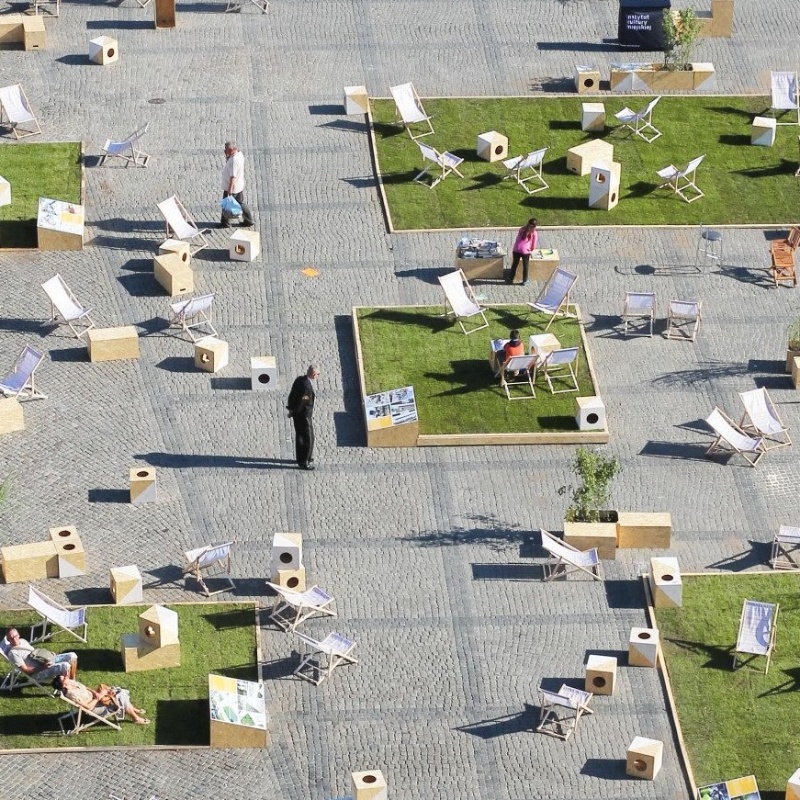
We believe the wise use of the public realm can drive successful developments, as much as the architecture itself. Our collaborative teams build strategies to create walkable, human-scale places with an enhanced sense of vibrancy and community.
In Scale, Physicist and complexity theorist Geoffrey West lays out the power-scaling laws common to biological and human social systems. His findings suggest underlying constraints on living systems having to do with the distribution networks that supply nutrients to cells, leaves, and limbs. The central insight is that these hidden laws govern the life cycle of everything from plants and animals to the cities we live in.
Cities as a Network for People
Echoing this insight, for sociologist Manuel Castells, the key paradigm shift is to ‘redefine cities as eco-systems, and to explore the connection between the local eco-system and the global-ecosystem.’ We argue here that this way of conceptualising the city, has deep resonance, revelatory power and a far-reaching problem-solving capacity.
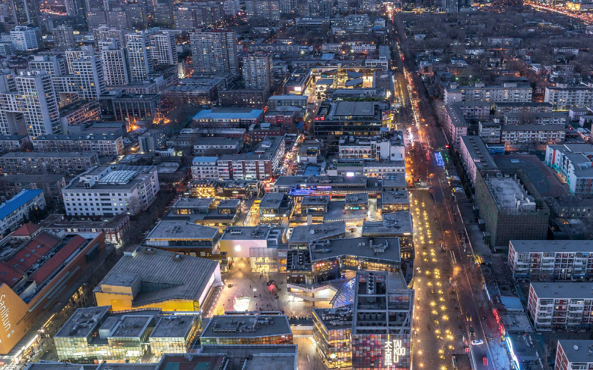
At Oval, people-centric Placemaking has been championed for over 25 years. Known for successful open-air retail developments such as Beijing Sanlitun and Taikoo Li Chengdu, on the surface, The Oval Partnership is an urban planning, retail planning, architecture and interior design firm. But scratch the surface and we are forward-thinking, keen researchers of people, community, sustainability and story-telling.
In a fundamental sense the success of the interdisciplinary practice has been to celebrate and understand the street’s role as for people, and by people. As a city innovator, we continue to put genuine sustainability into tangible practice. By transforming abandoned and run down public spaces and setting up community initiatives we are reenergising shared civic feeling. But we are not stopping there.

We structure teams that fuse the disciplines of architecture, landscape, urban and transport planning to writing and data analysis. Our Storytelling and urban narrative approach allows us to place important emphasis on behaviour by emphasising the importance of behaviour on place.
In the contemporary city, this behaviour is now both online and offline. For sociologist Manuel Castells: “From the point of view of the urban experience, we are entering a built environment that is increasingly incorporating electronic communication devices everywhere. Our urban life fabric...becomes an e-topia, a new urban form in which we constantly interact, deliberately or automatically, with online information systems, increasingly in the wireless mode.”
As people increasingly turn to the internet to make their purchases online, traditional retail continues to decline. As Marshall McLuhan foretold with his phrase ‘the medium is the message’ when dislocated from our grounded experience, social media deprives discussions of context and limits our capability to connect to others—it privileges the snackable and sensational and demotes the nuanced and empathetic.
Grounded in our shared memories of place, narratives are a powerful way for experiences to persist online, and our interwoven stories forge rich shared moments that take root in special places that we can and do return to. Through this, our goal is making thriving spaces and places conducive to life that stem—and indeed harness—the transformative technological advances as a powerful agent of socio-spatial change that Castells and others describe where; ‘Advanced telecommunications…are ushering in a new geography of networks and urban nodes throughout the world…and within metropolitan areas.’
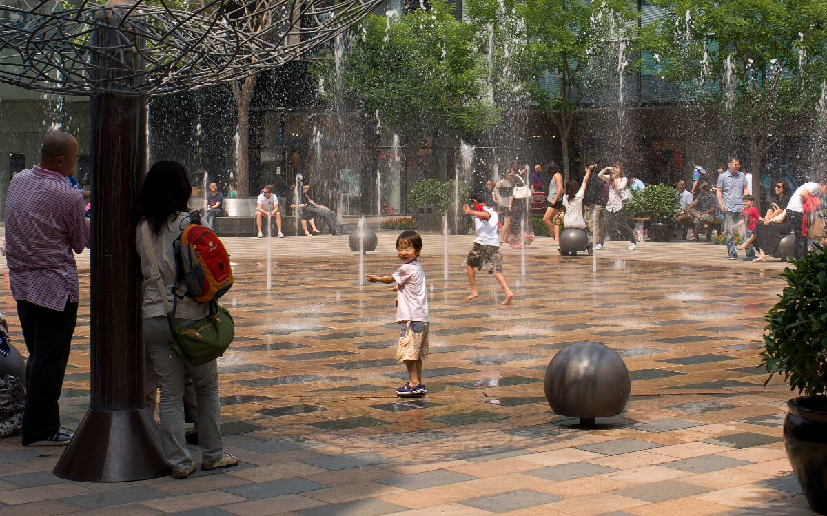
A growing number of the millennial generation are drawn to collaborative environments not tied to specific employers or institutions or fixed spaces, and instead are choosing revitalised urban neighbourhoods as spaces to live work and play. In the words of Jan Gehl:
"We know too little of about what makes good public space. Also internationally, we need research that can provide a platform for the qualitative planning and design of public space… Over the years urban activities have changed character and new user groups have appeared. Whereas public life in public space used to be dominated by necessary activities, today optional and recreational activities are high on the agenda."
We recognise walkable, vibrant streets are desirable. Electrified mass transit, ride-sharing, and bike-sharing are all beneficial and are vital to the continued success of cities for all generations. But it is by borrowing concepts from network theory that we can illuminate the topology of our human-centric system and evidence our intuition as to how to build better.
How to comprehend the city as network? As Castells states “no place exists by itself, since the positions are defined by the exchanges of flows in the network.” To emphasise this he states: “Thus, the network of communication is the fundamental spatial configuration: places do not disappear, but their logic and their meaning become absorbed in the network”.
New Thinking, Reinstating the City
Conditions must be right for cultivating change. Air pollution is now believed to kill more people than smoking. Across Europe it’s estimated to cause the premature deaths of 800,000 people a year.
Private cars sit parked 95% of the time. In fact, a single car usually occupies at least two parking spots: one at home, another at work. The prominent car-oriented model has resulted in structural and therefore persistent change to the fabric of the city. Roads and intersections are part of public space and in Los Angeles it represents a staggering 60 per cent of the space used. Indeed, codified, this impoverished, disjointed development model advocated by an investment real estate orthodoxy of segregated profit centres is fuelling rapid, ill-considered and unhealthy growth in Asian cities. Particularly for those affected, it is imperative this generationally outmoded mindset is retired and we formulate and rally around the new, more complete, accessible and humane urban development models.
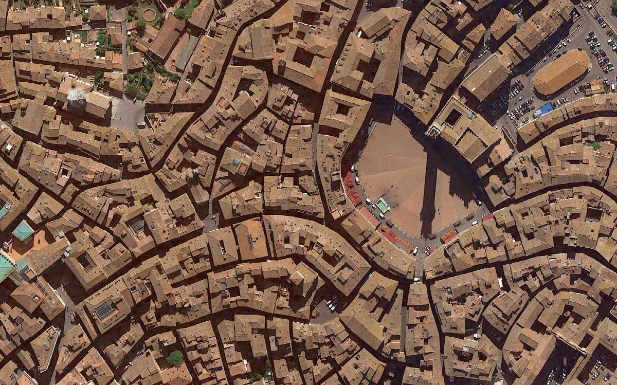
The fine scale of the urban block is vital for walkability. Street life must not be treated as an impediment to traffic. For Castells; ‘The key endeavour of planning in the metropolitan regions of the information age is to ensure their connectivity.’ In his book Urban Acupuncture, progressive city thinker Jaime Lerner invites us to re-examine the true building blocks of vibrant communities—the tree-lined avenues, night vendors, and songs and traditions that connect us to our cities and to one another. This transformation of the urban grain is an imperative, neither individual electric cars nor driverless cars will return the city to people-centric densities of occupation. For Castells, public space “is the key connector of experience, opposed to private shopping centers as the spaces of sociability.” As Lerner sums up; “The revolution in how we live and work throws up all sorts of new possibilities and problems while existing systems of thinking cannot analyse, explain and solve current situations.”
At Oval, ‘Open Cities’ is our model which seeks to promote clean energy and an empowered citizenry and demote or replace the private car. Higher densities can facilitate more sustainable public transport, walking and cycling, enabling efficient provision of services and promoting urban vitality—with sufficiently considered, high quality urban design. We endorse Castells’ view that the strategic objectives must align toward ‘providing spatial meaning by a new symbolic nodality created by innovative architectural projects; and reinstating the city in its urban form by the practice of urban design focused on preservation, restoration, and construction of public space as the epitome of urban life.’
Big Data: Harnessing Potential for Placemaking
We have long looked to urbanists and architects such as Jan Gehl — who strive to reclaim the space now captured by cars, to allow “life between buildings” to thrive. In the contemporary city subject to a globalising dynamic, leveraging the power of Big Data for the populace, we can realise the potential of this network approach to chart human behaviour at scale and in near real-time.
In our interconnected world generating ever more data, it is essential this wealth of information is used to the benefit of all. Emergent patterns teased from Big Data and can inform the design of our reimagined urban neighbourhoods. We leverage datasets beyond simply consumer activity or footfall. By bringing in broader geographic data relating to geography, demographics, land-use and demand data, occupancy patterns emerge that provide us with unprecedented insight.
The Challenge
Access to shared data is crucial for informing and improving tech-enabled urban innovation. The primary challenge regarding the use of big data in cities is how it is interpreted – both intelligently and securely. Principled use of data allied with best-practice data security is paramount. As a prerequisite, at Oval stringent and robust processes are in place to ensure thorough prior anonymisation and aggregation of all datasets. Of course, clear communication with all stakeholders is vital, and fortunately Oval has strong roots in engaging citizens via community consultation and compelling storytelling. The key is to mobilise stakeholder consensus around “an urban design capable of connecting local life, individuals, communes, and instrumental global flows through the sharing of public places.”
The Potential of Place—Visualised
We are passionate about bringing this new understanding of public space to the populace by working toward an evidence-based evaluation of planning and design of places to enhance the decision-making process and generate solutions. Underpinned by the physicists’, sociologists’ and urbanists’ theories cited, the toolset we use is Digital Placemaking.
Digital Placemaking is a term we coined to encompass a set of data-driven processes harnessing place and people data analytics. Underway for 3 years, the endeavour is to craft a toolkit for spotting emerging urban patterns—location intelligence if you will—and to capitalise on them through design and place curation for all to benefit. Our pilot projects are showing huge promise.
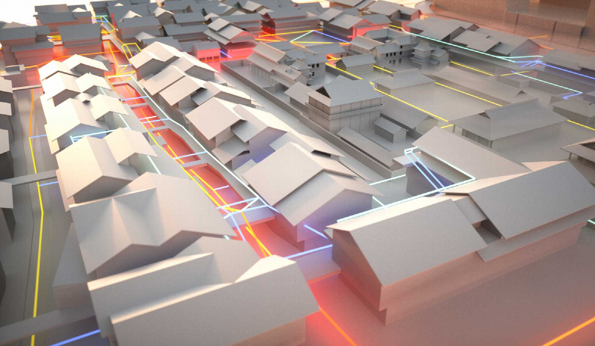
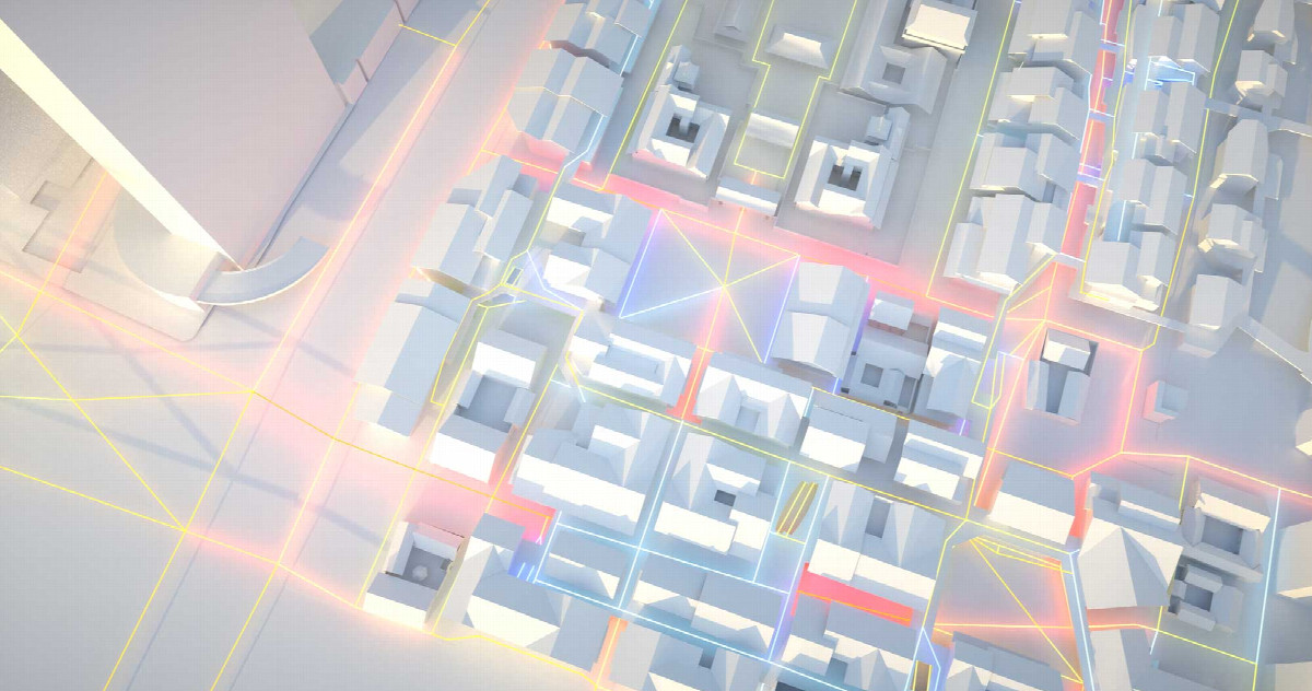
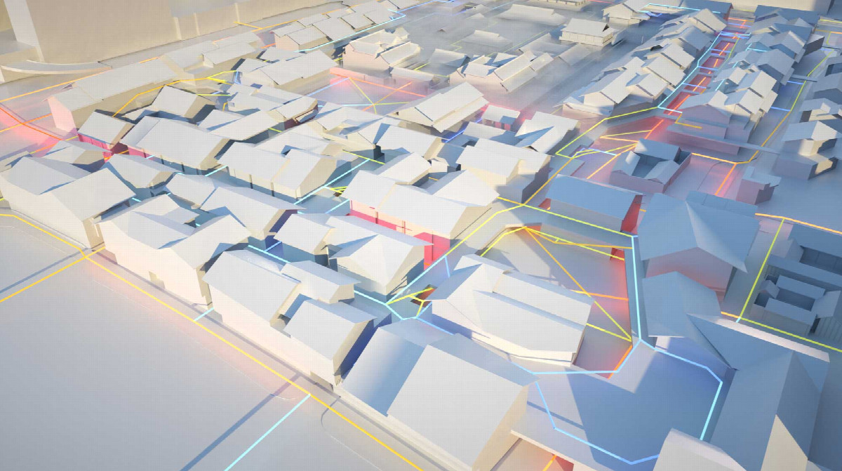
First, using spatial pedestrian network analysis allows us to compute accessibility and predict flows for walkability and people-centric sustainable transport. A window can be opened onto the underlying dynamics of the intensely global yet inherently local layered system that is today’s urban network.
Second, employing a geo-located anonymous and generalised dataset of footfall and journey data, we can identify demographics, foot traffic and use pattern heatmaps in and around a location.
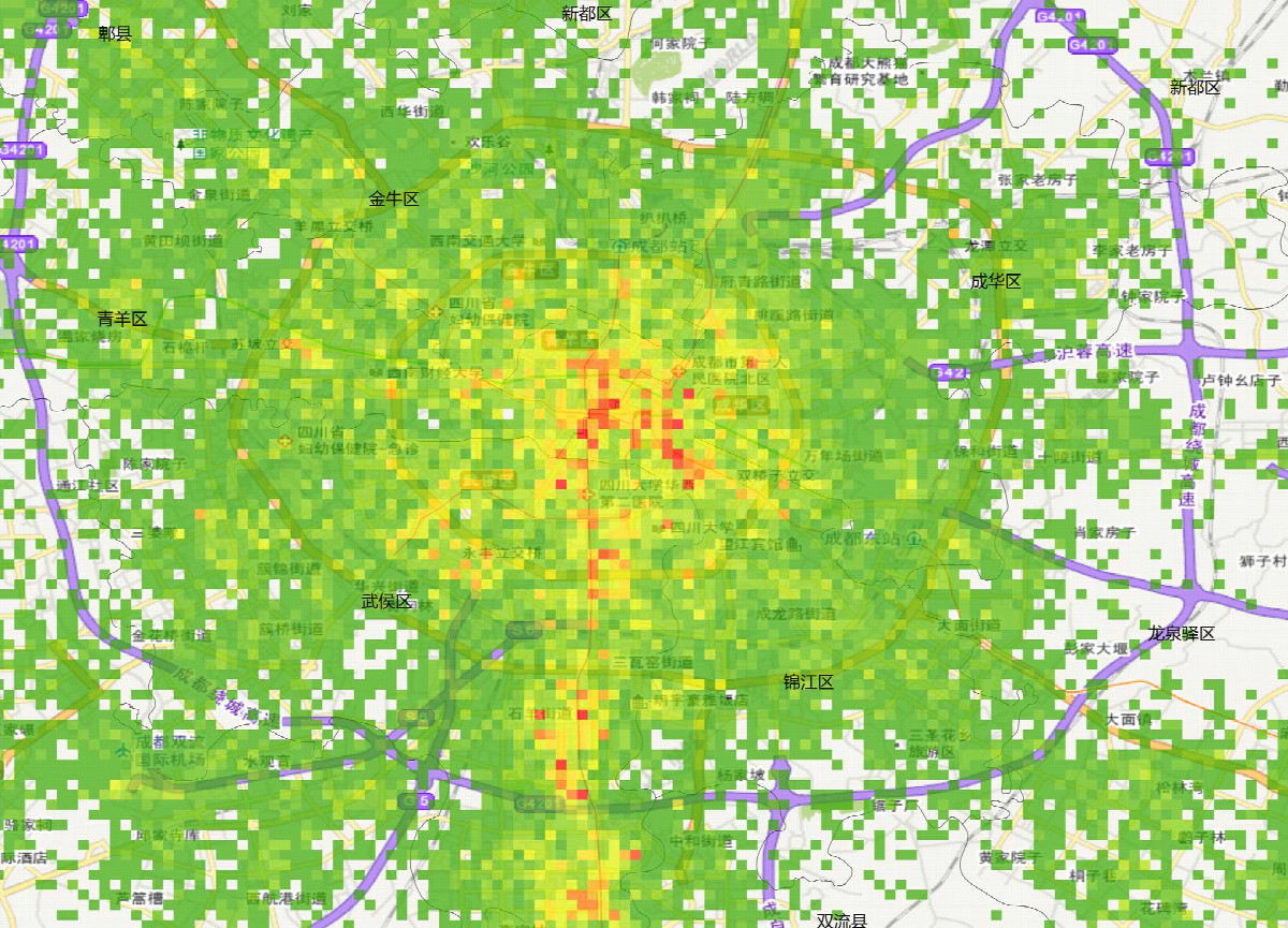
With these in tandem, we are developing weighted network analysis tools to create calibrated models of footfall at a neighbourhood level, which are used to test the impact of changes to layout or balance of uses. Once formed, the models allow us to identify activity nodes at different times and even forecast future footfall with the fastest growing urban trends.
“The process of reconstruction of the city is underway. And the emphasis of the most advanced urban projects in the world is on communication, in its multidimensional sense.” Along with a dose of architectural intuition, we can now pinpoint potential improvements to a development’s footfall, target market or offer—from conceptual planning stages to post-completion. This powerful iterative process allows us to feedback refinements to into our inclusive topological model of worker, resident and visitor movement, and then project a blueprint for quantifiable proposals that we and our clients can evaluate.
At the scale of the neighbourhood, we can then spot development trends in the urban framework and react. Or—in the terminology of the networked urban nervous system—we can measure, interlink and amplify the synergy of flows between people, organisations through place that powers innovation, personal growth and cements substantial experiences.
Unprecedented behavioral insights about human society and mobility can emerge from working with even medium sized datasets. They allow us to reimagine and then plan our cities better. This is a game-changing, powerful predictive toolset we are piloting now.
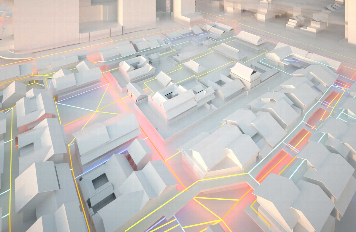
Our real-world case studies include; Regenerative urban planning in a neglected heritage district of a historic Chinese city. Here, a newly walkable fine grained route network is being sensitively transposed into the oversized city block to create a sumptuous landscaped setting for this revitalised quarter. This is then iteratively refined with predictive modelling toward an artful balance of rich offerings.
Elsewhere, a further forward-looking study involves the strategic expansion of a wildly successful heritage-infused downtown open-air retail district. Employing big data, we know 36,000 peak daily visitors more are visiting the site compared to the neighbouring blocks. With granular demographics, and using our predictive toolset, we have proposed new restorative routes to surgically and strategically reconnect and extend the city’s now-reinstated fabric. Future development is then teed up to catalyse the known potential growth in visitor numbers.
Getting the blend right is vital. ‘Sometimes the public space is a square, sometimes a park, sometimes a boulevard... Or an outdoor café colonising the sidewalk. In all instances what matters is the spontaneity of uses, the density of the interaction, the freedom of expression, the multifunctionality of space, and the multiculturalism of the street life.’ These are truly exciting times to play a part in the resurgence of fulfilling life in our cities.
Philip Clarke is Project Director for Digital Placemaking at The Oval Partnership.