China has expanded the metro networks of its major cities at an unprecedented pace over the last 25 years. High-capacity urban transit is essential to manage the growth of mega-cities in an environmentally responsible manner. Yet the quality of a transit network is also defined by the ease with which passengers can access it. The retrofitting of transit stations into urban areas designed around the needs of the car has in many cases resulted in poor station access. In this article, the authors argue that Chinese cities have not yet found a model of Transit Oriented Development that successfully integrates transit system planning and urban planning.
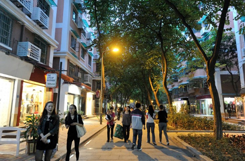
The urban fabric of many cities is a complex product of cultural norms and social attitudes, as well as the nature of the development process. The result has frequently been neighbourhoods dominated by gated residential communities and inward-looking commercial developments separated by wide roads. Working with The Oval Partnership, Wedderburn Transport Planning is using an evidence-based approach to develop context-sensitive forms of Open City Design that are culturally and commercially successful, while providing safe and comfortable access to transit stations.
Pedestrian Transport Planning for TOD in China
The 13th national Five-Year plan has defined quantitative targets regarding transport infrastructure, length of network, coverage, and mode share objectives. Public transport coverage is expected to reach 100% in medium and large cities, mode share should grow from 40% in 2015 to 50% in 2020. Public transport and active modes’ infrastructure are still growing exponentially. However, Chinese cities have arguably not yet found a form of TOD that successfully integrates transit system planning and urban planning.
Transit systems need to be integrated into a more comprehensive planning framework that integrates different modes of transport including non-motorised modes. MRT in Chinese cities has admittedly improved commuting, but the measures of success should not simply be restricted to speed and kilometres of lines but should also be focused on accessibility.
CHALLENGE I: Metro Stations are Retrofitted in the Existing Urban Environment
The general urban development model in most Chinese cities has been and continues to be large car-oriented superblocks. Thus, in many urban areas the metro system and its stations are subsequently retrofitted. For example, Wangjing is one of Beijing’s biggest residential neighbourhoods that started developing in the 1990s prior to the construction of metro lines.
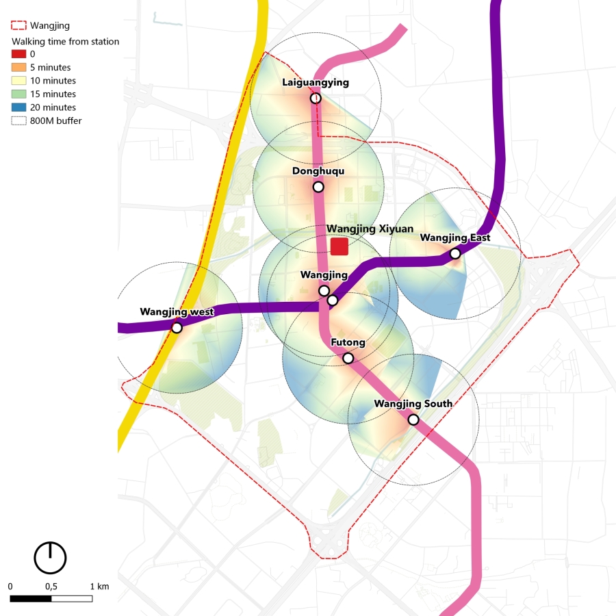
The Wangjing sub-district covers an area of 16 square kilometres and is home to more than 300,000 inhabitants. It is located 8m from Beijing city centre, and is enclosed by the 4th ring road to the south, the 5th ringroad to the north, the Airport expressway to the east and Jingcheng highway to the west, completed in 2001, 2004, 1993 and 2006 respectively. The area has experienced tremendous urban development in the past 30 years, from a suburb in the 1990’s to a new centre and emerging hub for tech companies in Beijing.
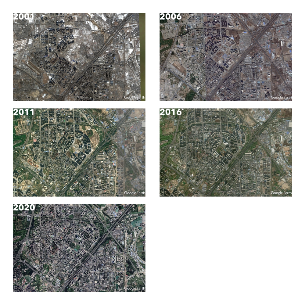
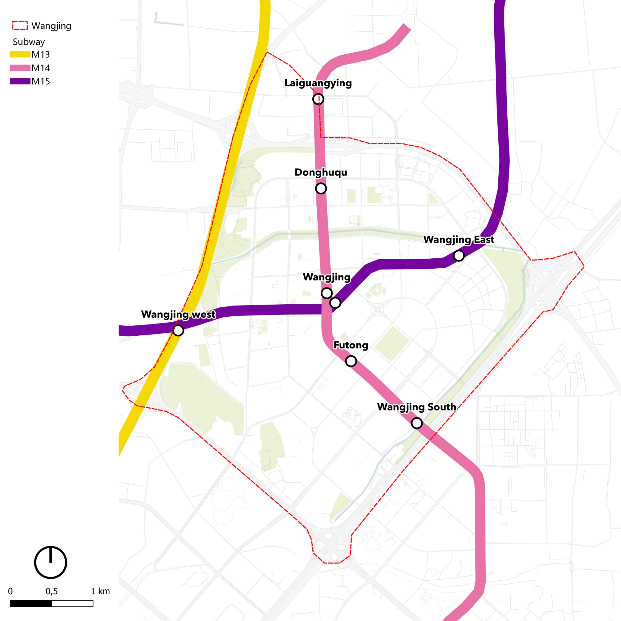
Line 13, the first metro line to be built in the residential district, was operational in 2002, serving its western part with one station Wangjing west. Line 15 and 14 were operational in 2010 and 2014, respectively.
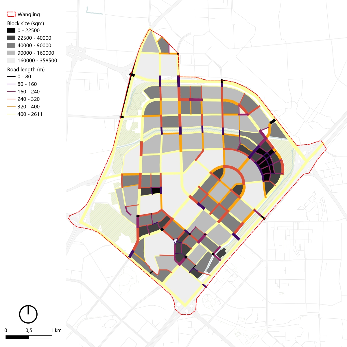
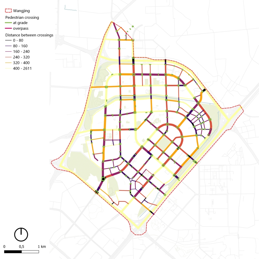
The Wangjing road planning system follows the Buchanan model, creating a hierarchy where in practice the needs of vehicular traffic are prioritised at the expense of pedestrians. This road network hierarchy has led to block sizes around metro stations that frequently exceed 300 x 300 metres.
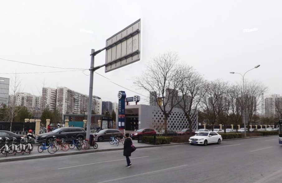
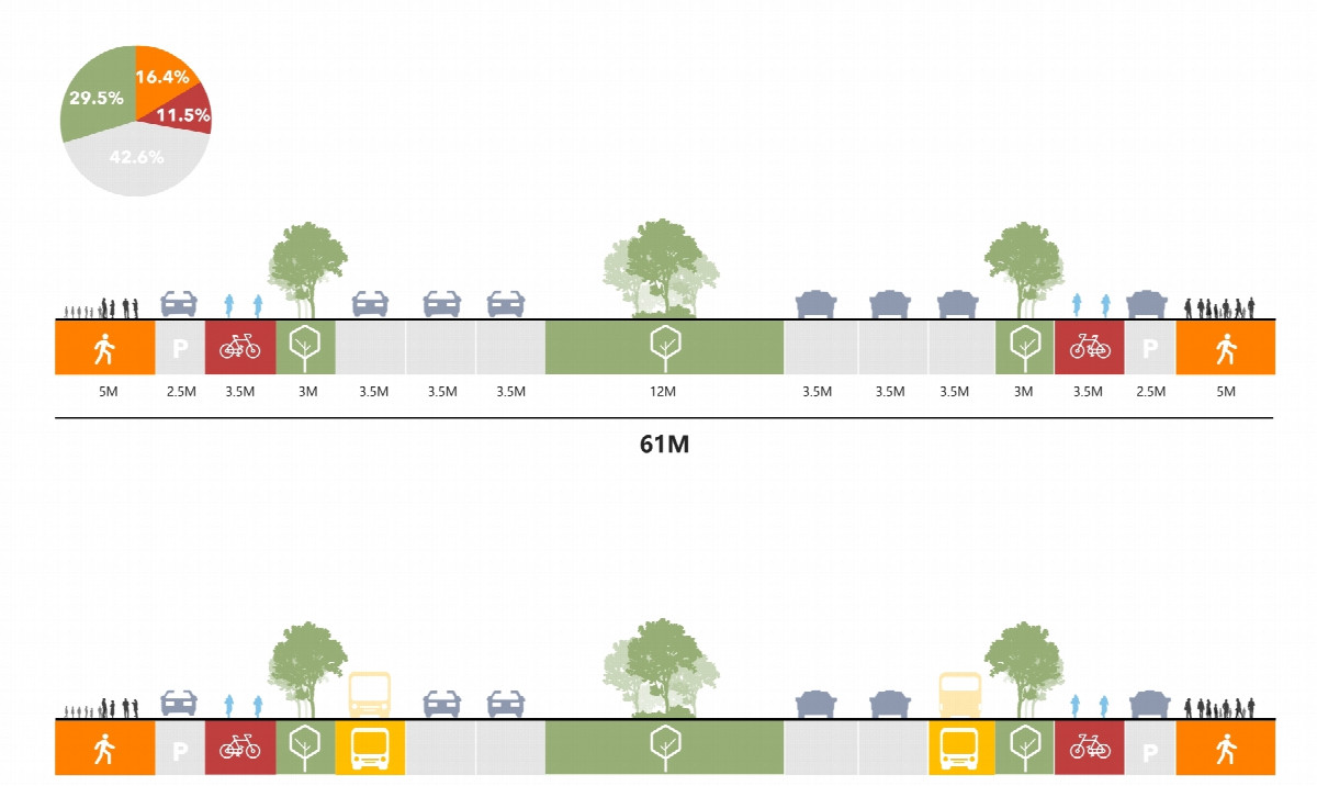
Metro stations are built along large roads where cars use most of the space, there is little reconfiguration of urban space to create a pedestrian friendly environment. On Guangshun North Avenue, pedestrian space accounts for 18% against almost 40% for motorised vehicles next to Wanjing Metro station.
In addition, the spacing between pedestrian crossings is large, averaging more than 190 metres which can create compliance and safety issues even around transit hubs where there is high footfall.
Large block development with gated communities has resulted in a poor density of pedestrian paths, forcing people to make detours to reach a station. The use of an 800m radius, measured as the crow flies, to describe the potential walking catchment around a station does not reflect the reality of the pedestrian network.
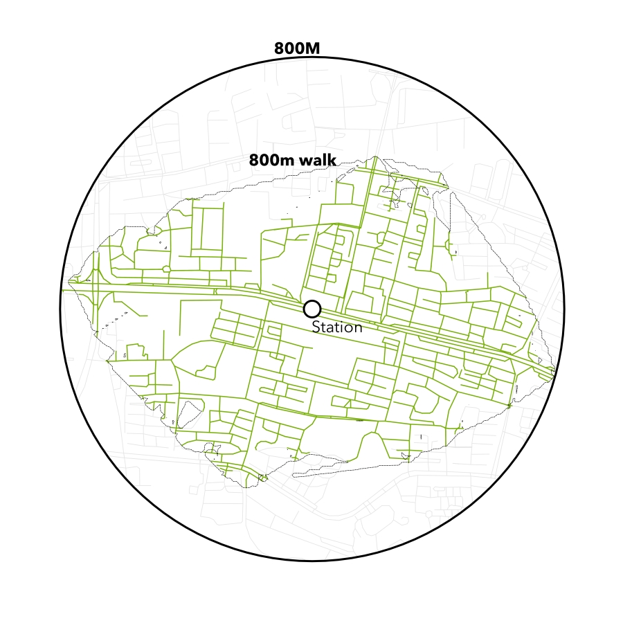
For example, Wangjing Xiyuan is surrounded by other gated developments, where gates and pedestrian paths are not aligned. Pedestrians living 600m from the station as the crow flies have to walk for 900 metres to access Wangjing metro stop, making detours through large roads.
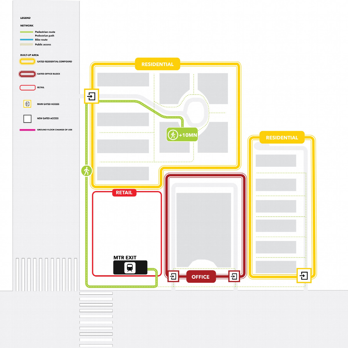
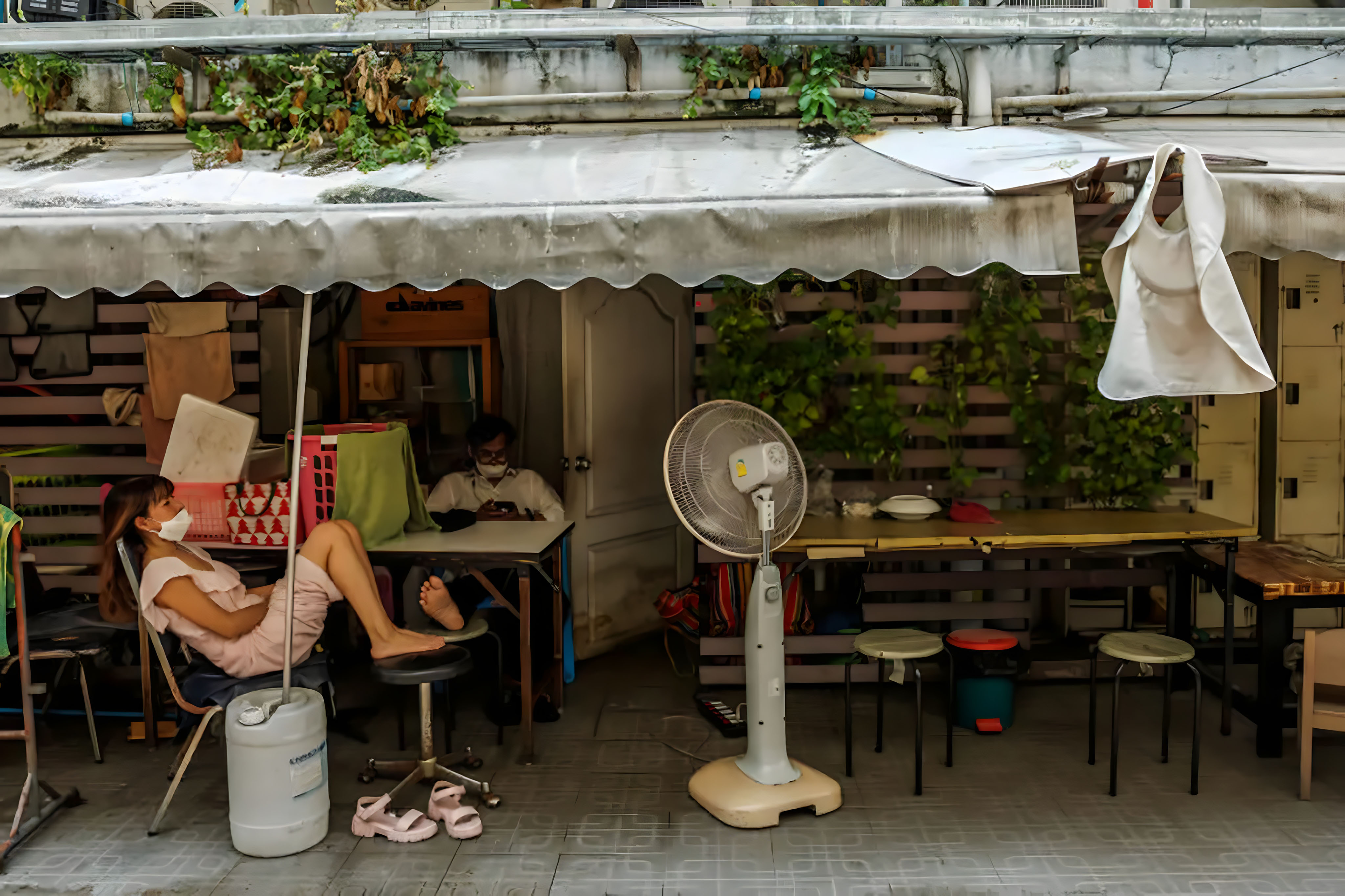
Some of the problems encountered in Wangjing are also found in new developments in some Chinese cities. New developments around transit stations (especially residential) are often designed as gated communities. Pedestrian access to the transit stations is rarely accorded much weight in the planning with car access being prioritised.
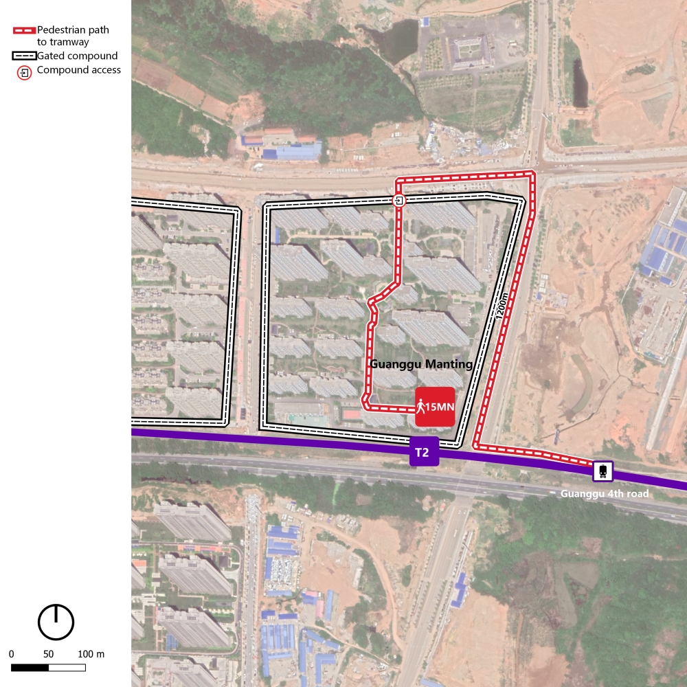
In the optical valley in Wuhan, tramway line 2 is built along the 4th ring road where space is constrained. New gated residential development entrances are not aligned with the tramway station. The closest entrances to the tramway station are on the north and on the east of the compound, resulting in poor accessibility to the station.
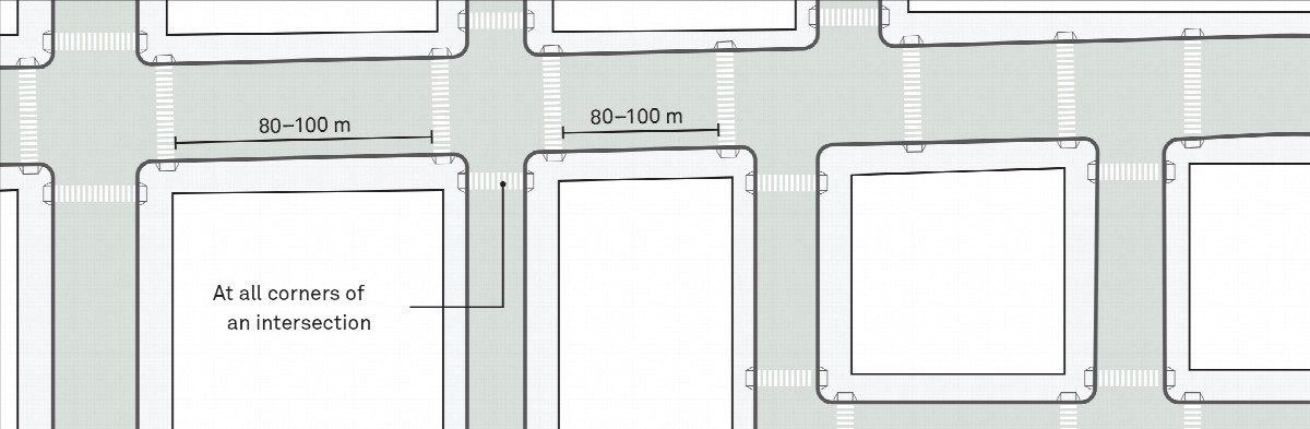
There are recognised international guidelines stating that to create a walkable and safe environment for pedestrians in urban areas, spacing should be between 80 to 100 metres and aligned with desire lines. The value of increasing the density of pedestrian paths around metro stations is increasingly being recognised as a means to disperse pedestrian flows, create better circulation and improve the environment for all users around stations.
The regulations regarding pedestrian crossing facilities are not user friendly. According to the national regulation GB50688 Code for design of urban road traffic facility, the spacing between crossings is defined by the (vehicular) function of the road. On primary roads the spacing should be between 300-500 metres and on secondary roads it should be between 150-300 metres. Spacing can be shorter in dense commercial, cultural developments or transit hubs. The regulation stated that all roads other than highways or expressways should prioritise at-grade crossings. Municipalities or Provinces can have their own local regulations and apply them instead of the National one. Regulations remain a coercive tool and are generally applied rigorously when infrastructure is being built.
A more nuanced approach to the regulations regarding pedestrian crossings can be found where Municipalities adopt design guidelines for specific corridors. For example, the street design guidelines in Xi’an include character typologies along a major corridor, recognising the need for varying solutions to balance the needs of pedestrian and vehicles in different character areas.
CHALLENGE II: Urban Planning and Transit Network Planning are not Always Integrated
The whole journey of a passenger includes accessing the station, the time spent in the transit vehicle, potentially interchanging between transit modes and exiting the station to reach a destination. While on a strategic level, public transport is efficient, fast, safe, and reliable, accessibility to stations is often not considered as part of the journey.
In a 2017 paper published by the World Resources Institute (WRI) comparing Chinese BRT systems of 24 cities with International BRT systems, it was found that the systems performed poorly in the sub-category “Integration and Access” especially for pedestrian and universal access. The study uses the Institute for Transportation and Development Policy (ITDP) indicators to evaluate and compare BRT systems. The results show that Chinese BRT systems are 35.5 and 70.6 points below international mean for pedestrian and universal access, respectively.
A door-to-door approach to transport planning means that all the steps of the journey should be considered to create attractive public transport. In practice this approach means that pedestrian routes to access public transport stations should be considered alongside the strategic route planning, as part of an iterative process.
Metro stations are often constructed at major intersections where space is available for their construction. In an environment of urban superblocks surrounded by wide roads, locating station exits at a major intersection is a means of providing access to surrounding communities. Yet this strategy can place pressure on the constrained pedestrian network around stations.
In practice the pedestrian network is constrained around many stations and the only option for pedestrians is to follow the main road network. There are many competing uses for space around the station exits near to these major intersections. This creates crowded conditions for pedestrians, vehicles and other users of the space. For example, Dongdaqiao intersection in Beijing close to large office and residential developments is often crowded at peak hours. New metro lines are under construction and their work sites overlap the pedestrian paths, creating an unsafe environment for pedestrians, bicycles and cars.
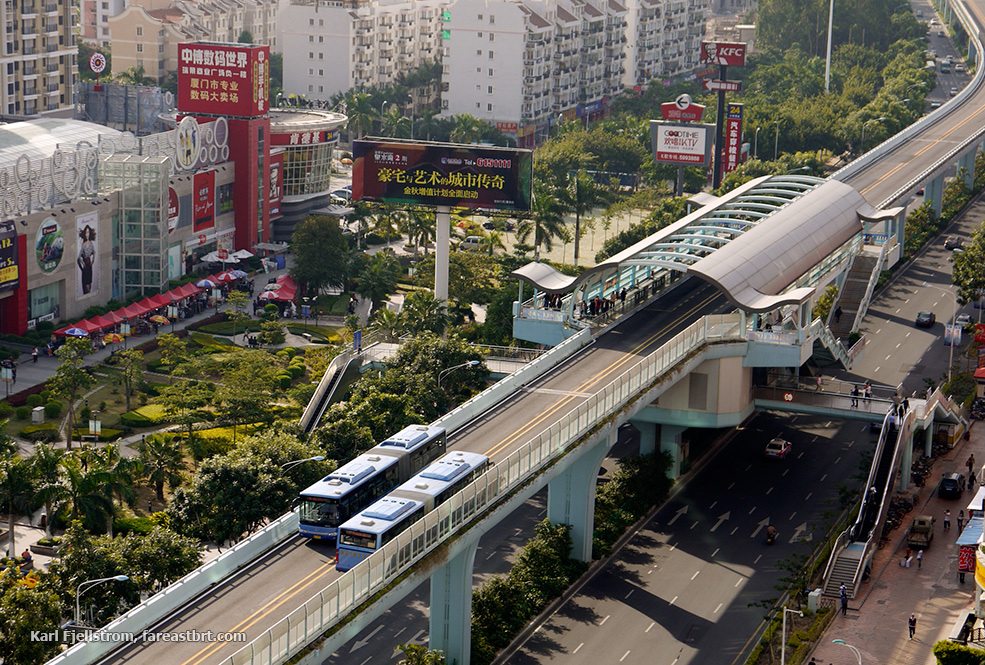
Issues of pedestrian access are not solely reserved to underground metro systems and apply in the same way to surface and elevated systems. In cities where tram or bus rapid transit systems have been implemented, the regulations around the physical barriers separating on-street transit systems from general traffic can also result in limited pedestrian access to the stops. For example, Xiamen’s elevated BRT might have a higher operational performance than other BRT systems since it is not impacted by vehicle traffic. However, multiple stairs and overpasses result in limited access for people with reduced mobility.
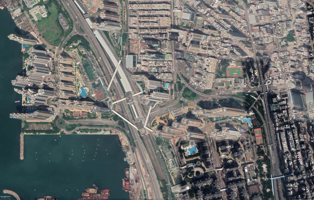
The prime example of a very different development model is seen in Hong Kong. The expansion of the metro system involves the government granting development rights to the MTR who finance the construction through the land value uplift and property development. This has resulted in a typical spatial development model where retail and service malls are integrated with the station, spanning out in a star shape to the residential compounds constructed around the station. There is an incentive upon all parties to optimise access to the MTR station to maximise development land values and operator revenues.
CHALLENGE III: Poor Station Access Harms the Business Case for Transit Investment
Retrofitting a metro station into an existing urban environment is more challenging. Not only is the physical cost of construcion higher when working around existing communities and movement networks, but fragmented land ownership and stakeholder interests add significant legal and commercial complexity.
This situation does not help with the case for transit investment. Until recently, transport investment in China has been focussed heavily on inter-urban highway and high-speed rail networks. As these networks reach completion in key regions, the return on investment for these project types is decreasing. Investment in Belt & road Initiative projects and urban transport systems have the potential to offer higher returns. Poor accessibility to public transport stations and stops has a direct impact on the investment case MRT systems since it reduces potential ridership and thus revenue, resulting in longer than necessary payback periods for the return on investment.
The potential value capture from the immediate over-station development can be limited because station infrastructure reduces the leasable area. With optimised pedestrian access to the station, it is therefore the adjacent developments that are crucial to land value capture. The gated communities’ spatial model where the compounds immediately adjacent to the over-station development are not physically connected, do not maximise the station catchment and are therefore not conducive to land value capture mechanisms.
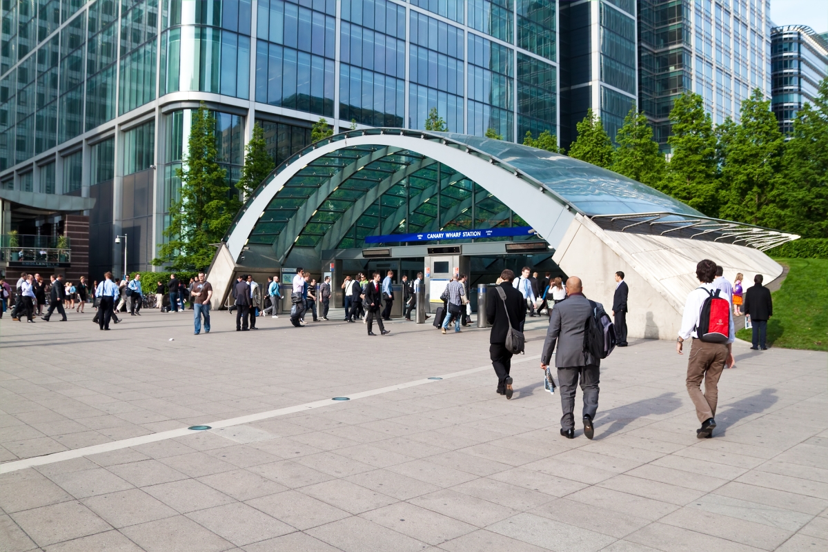
Moreover, while inter-urban transport infrastructure has been financed through short term commercial loans, it is questionable whether investment in urban transport systems can rely on the same funding model. Urban transit systems generate huge windfall gains in land and property values. For example, the scale of property value increase around just two stations on the Jubilee Line extension in London - Canary Wharf and Southwark – over the first three years after opening was estimated at around 18bn RMB. Appropriate land value capture mechanisms therefore present an important part of more sustainable funding models.
Land and property values are highly correlated to the walking distance to stations. For example, recent analysis of residential sales by UK mortgage lender Nationwide estimated the premium buyers pay to live within easy walking distance of a station. In Manchester, a property located 500m from a station attracts a 100,000 RMB premium (7.8%) over an otherwise identical property located 1,500m from a station, and this premium rises to 350,000 RMB (9.4%) in London.
POTENTIAL SOLUTIONS
1. Improved Management of Last-mile Solutions
Longer walking distances from gated compounds to transit stations have created a market for last-mile mobility solutions in Chinese cities. Bicycles and micro-mobility vehicles such as e-scooters can be purchased as personal vehicles but are frequently offered as dockless Mobility as a Service (MaaS) systems. The ability to quickly unlock these vehicles through an app and leave them at the destination makes them particularly appealing for last-mile transit access trips.
Several years ago, there was a ferocious proliferation of bike hire operators seeking to gain maximum market share, which was followed by a sustained period of industry consolidation. Public perception of the bike hire industry was also tarnished by cluttered footways, examples of poor vehicle maintenance, media stories of bike graveyards, and by the lack of the integration of these systems into the wider public transport offer. The key MaaS operators on a global scale are also yet to demonstrate that they can generate sustained profitability.
These last-mile modes do have a potential role to play in improving access to transit stations. The consumer would, however, benefit from greater coordination with public transport, a sustainable financial model, and better management of parking at stations and in private developments. As the market matures some positive developments are emerging globally, including multimodal offers with e-bikes and e-scooters offered on the same platform, integration with public transport ticketing and multi-modal apps, and regulation of parking through physical and digital (geo-fencing) regulation.
2. Open City Design Concept
A recent paper explored the potential impact of ungating in a single neighbourhood in Hongkou, Shanghai. It concluded that the reduction in pedestrian delay that could be achieved through increased permeability equates to an annual societal benefit of 3.9m RMB using the monetary values of time for business/commuting and leisure travel as employed in the economic appraisal of other transport modes.
While the potential benefits are huge, is there a form of ungating that would be acceptable to existing residents? It is commonplace in TOD developments around the world to provide direct access to public retail areas from office buildings and hotels, accessed via security gatelines using key fob or more recently facial recognition technology. It can therefore be possible to improve access to a metro station for residents (or employees) of one development by enabling access through an adjacent site by agreement of both landowners and using access control technology.
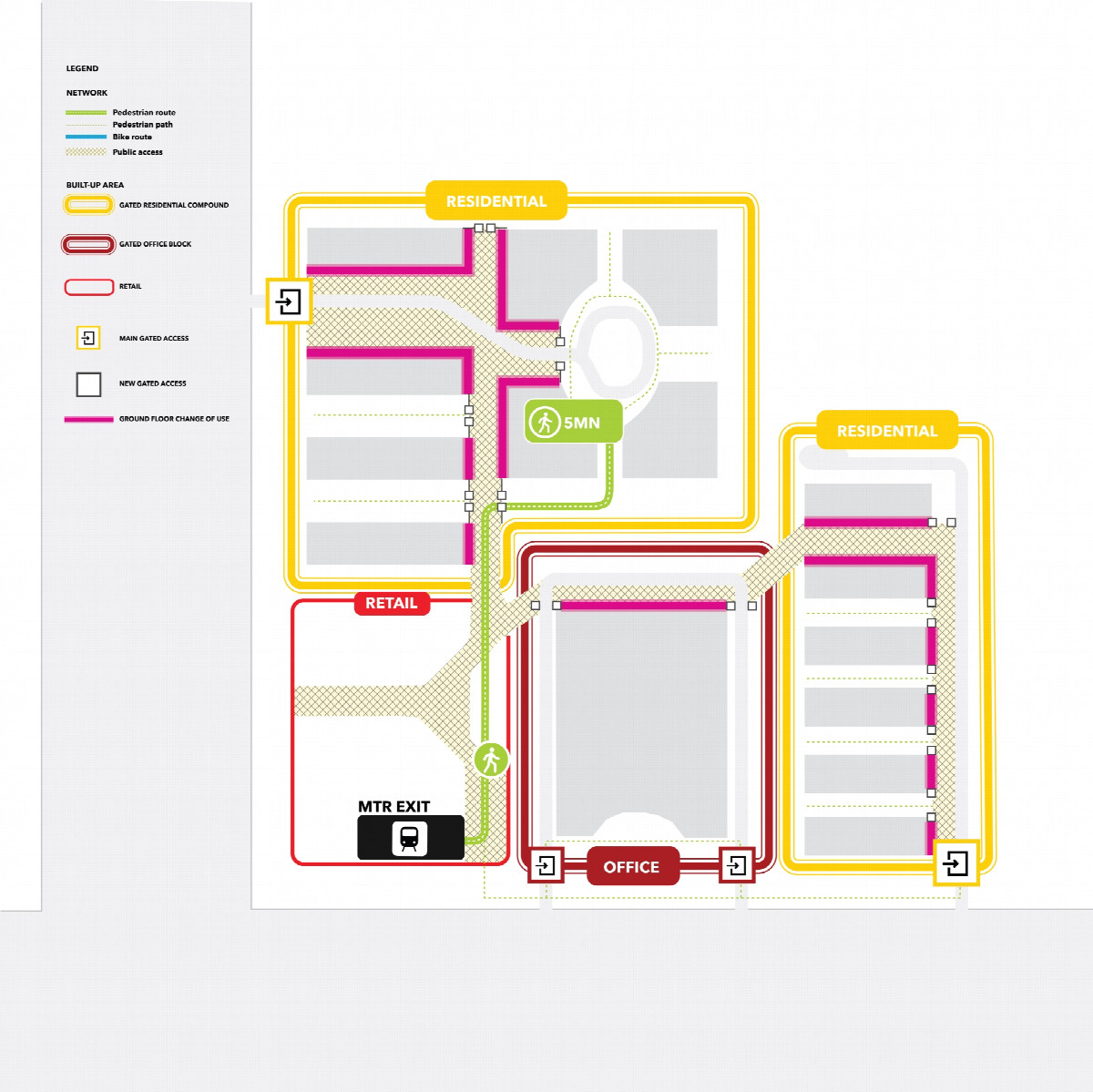
This arrangement can also be beneficial for both landowners. Consider the example of an over-station development with a retail mall podium surrounded by gated developments. The walking detour to the station also affects the mall and it may struggle to capture what should be captive footfall.
Residents of the gated developments benefit from a quicker route to the station and to the mall. The mall owner benefits from the footfall of adjacent developments and can position itself as a 21st century neighbourhood mall.
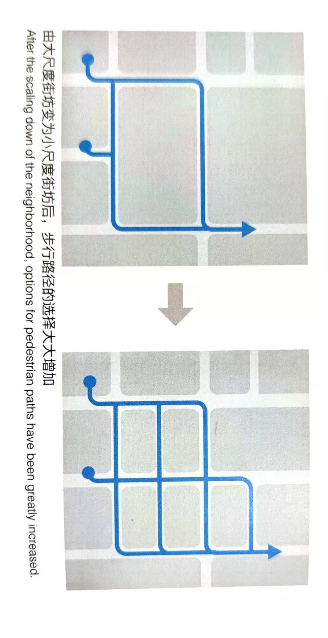
In the medium-term, new development models are emerging that are more integrated into the urban fabric. TODs have great economic potential if public attitudes become more accepting of benefits of good pedestrian access around stations. They can provide higher quality public spaces, safer routes and attract more footfall to commercial areas, creating more inclusive neighbourhoods.
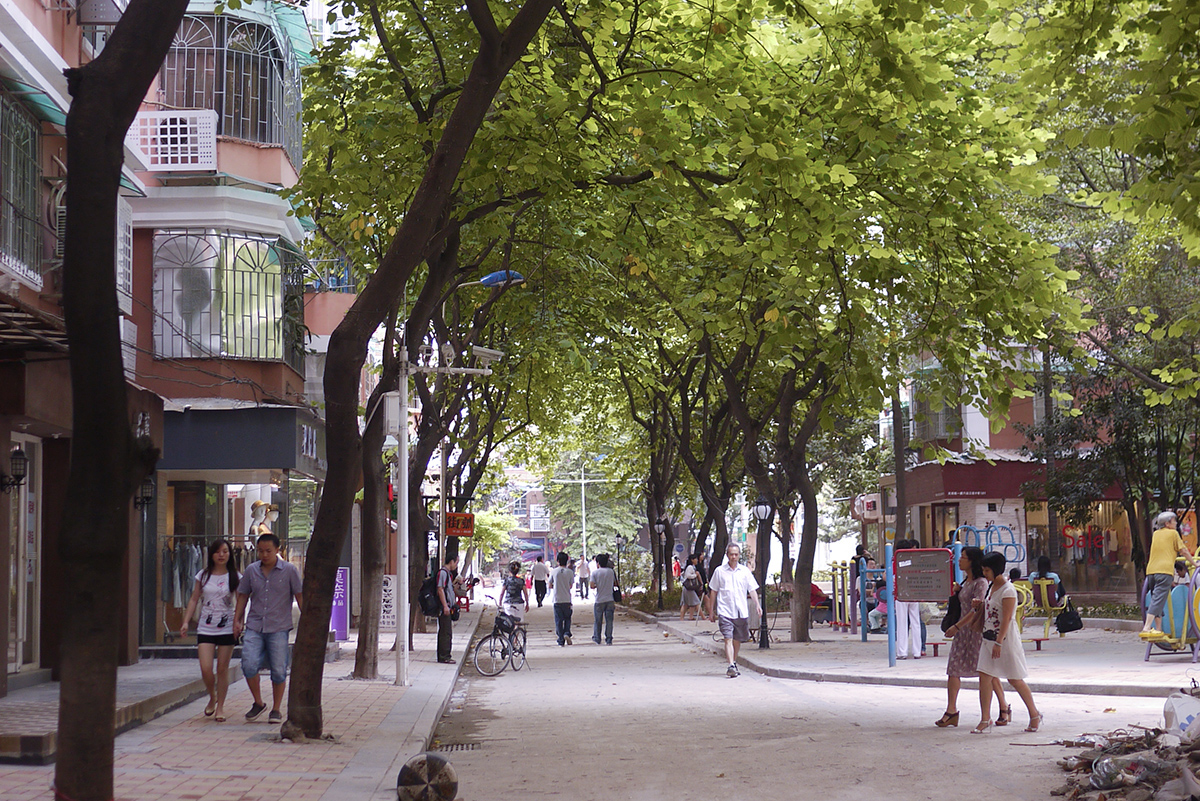
Open city design concepts provide an alternative development model to gated communities offering enhanced connectivity, safe and attractive public realm, a greater mix of uses.
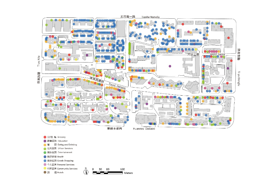
One successful example of urban integration is the Liuyue compound in Guangzhou. It was regenerated during the 2000s and is now an active neighbourhood that is well-integrated into the urban fabric. It is located near BRT and metro stops, providing greater accessibility for public transport.
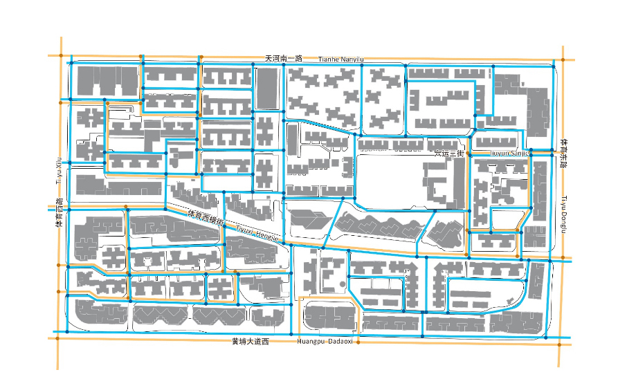
The residential block is open, improving pedestrian connectivity within area. Two measures balance connectivity with semi-private space. Firstly, buildings always retain private controlled access. Secondly, timed access control is used and public access to some blocks is closed at night.
Most of the alleys in the compound are now car-free, providing safe environments for pedestrians and cyclists. Moreover, ground floors units have been converted into small retail units, services or schools providing a mix of use inside the compound.
3. Transport Planning Policies
Many national and city guidelines have been published to show best practice in the design of TODs, such as the “Planning and design guidelines along urban rail” produced by the Minister of Housing and Urban-rural development (MOHURD) in 2015. However, if regulations do not evolve, urban development patterns will not change. Current regulations still prioritise vehicular traffic capacity and speed, even in TOD areas. A fundamental policy change is necessary in the fields of urban and transport planning.
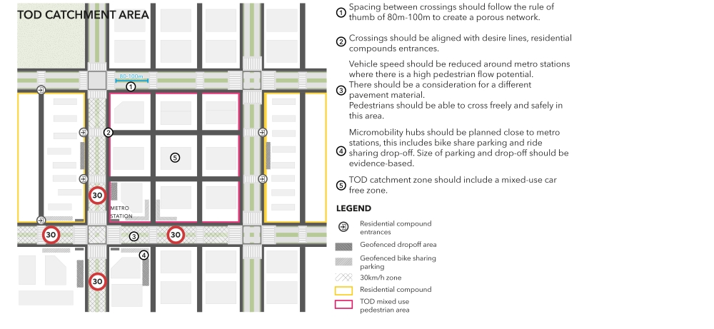
Firstly, cities should define clear principles and regulations according to different urban character areas, such as dense CBD zones, other high-density centres, Transit oriented development, etc. Policies aimed at harnessing maximum benefit from TODs and pedestrian oriented planning regulations should be applied within this framework. Station catchment areas where TOD regulations apply should be clearly defined. The catchment areas should be applied based on the existing or planned network of streets and paths, and not a crow fly buffer.
Secondly, street design regulations should be differentiated by character areas, hence different street regulations would be applicable in TOD catchments. For example, the flow of pedestrian movement on a primary road in a dense and mixed urban setting will be higher than the flow of movement on an equivalent primary road in an industrial zone. Pedestrian crossing spacing regulations should be adjusted according to the character of the urban area and not only according to the vehicular movement function of the road.
Finally, incentives could be offered for developers to optimise access to metro stations within TOD catchments. This can be instrumentalised by allowing higher density and greater flexibility over the mix of land uses in locations in close walking distance to the station. This places the onus on developers to optimise access to public transport if they wish to maximise the long-term value of their sites.
In new-build areas, the Rail + Property model used in Hong Kong could be applied in other cities where the property development rights of government-owned land can be sold at a “before-rail” price. This development model also integrates different phases of the development, ensuring coordination between the different parties, smooth project implementation and transaction costs reduction.
4. Transport Planning and Accessibility Tools
Transport assessments should not simply be box-ticking exercises to appease traffic engineers in municipal government. They are an integral part of the masterplanning process and, if applied with care, they can maximise value for landowners while at the same time creating additional value for the local community.
This means a focus on accessibility rather on mobility for its own sake. Tools to analyse connectivity can and should be used at a range of scales, starting from walking routes to local services and facilities right up to access to national and international transport hubs. These tools could be incorporated in street design regulations or TOD catchment regulations to assess the pedestrian network.
Wedderburn Transport Planning employs a range of tools and metrics to maximise access to public transport stations and stops, and to create connected and legible neighbourhoods that work at the human scale. We demonstrated this approach in the Oval Partnership submission for the Shenzhen Bay Cultural Plaza.
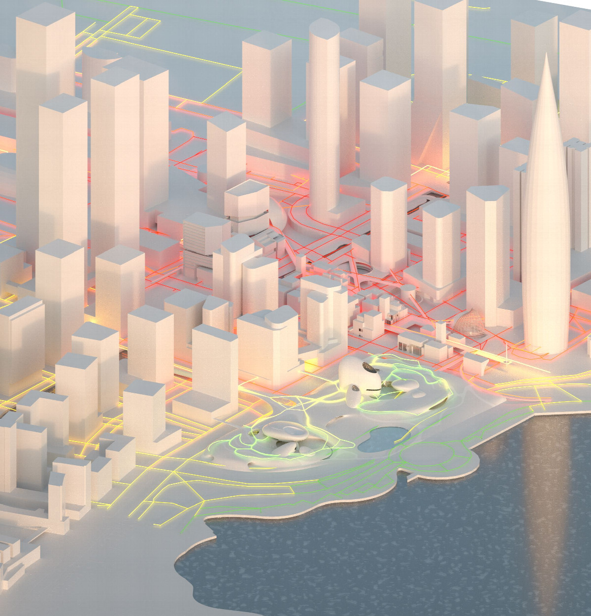
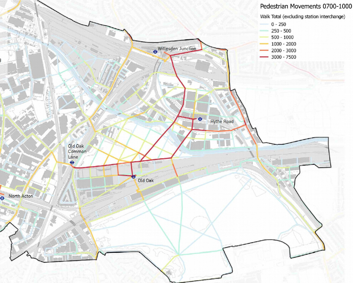
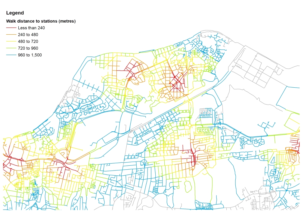
We have also developed pedestrian network planning tools that integrate with strategic transport models, for example integrating a new commercial centre and residential district with several stations for the Old Oak and Park Royal Development Corporation in London.
Authors
Georgies Srour is an experienced urban planning consultant who he perceives transport and urban mobility as a catalyst to create more sustainable, more active, and people-oriented cities. Having worked in China for a few years and with a strong interest in Chinese culture, he seeks to redefine transport planning practice in Chinese cities. Since joining Wedderburn Transport Planning, he has been working on using Big Data and advanced spatial analytics to provide evidence-based movement services to several major masterplans including Shenzhen Bay.
Martin Wedderburn is the founding director of Wedderburn Transport Planning. He has extensive experience in public transport network planning, pedestrian movement analysis and transport business case development. Recent projects in London include the Old Oak and Park Royal connectivity study, and the outline business case for a planned Docklands Light Railway extension to Thamesmead to enable new housing development.
Wedderburn Transport Planning is The Oval Partnership's strategic partner to develop Digital Placemaking. This article was first published in Urban China.